31st August
The E4 Trail: Katsiveli, Pachnes to Kallerghi
(To Pachnes and back : 4 hrs 10 mins 12.1 km)
Total day (including Pachnes - 2,453 m) :
Mov av 3.3 Time 9 hrs 30 mins GPS reading 25.3 kms Height 1518 (Kallerghi) (max 2,453 m)
The first time that I went up Pachnes from Katsiveli with T, the snow drift on the way to Roussies had blocked our path and we had had to climb up high to go round it, effectively climbing the height of Pachnes twice - with packs.
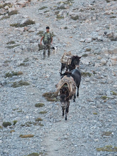
This time, in August, I was able to leave the body of the pack in the hut and the path was clear. It was another spectacular clear day with just high pressure haze on the horizon. It was a two hour walk to the summit along paths that seemed like motorways compared to the day before. On the way I crossed the mule train that makes its way to the Petrade mitato to collect the cheese. It is an almost biblical sight and one which will continue as long as the dirt road is not extended beyond Roussies - three well cared for mules and the young Cretan lad in charge of them.
 |
| A clear morning on the way to Pachnes |
 |
| The mule train |
 |
| The summit of Pachnes |
It was a good morning for photographs and I took my fill before turning back for Katsiveli hut and the rucksack. There is a more direct path back to Katsiveli (you can see the big hut from the summit) but I just didn't have the energy or the time to start exploring at this stage. It is still four or five hours on to Kallerghi so I went back the usual way via Roussies (where there is a fairly reliable cistern) and joined the two bits of the rucksack together, rested for twenty minutes and set off again on the well-trodden E4 path to Melindaou and Kallerghi.
 |
The view from the summit -
the EOS hut is on the saddle to the left of the conical one |
This is one of the two main routes into the heart of the White Mountains (the other being the dirt road from Anopoli to Roussies) so it is easy to follow and little time is lost on navigation. After rounding Melindaou - having stopped to admire the huge deep bowl which feeds into the Samaria Gorge - there is a simple descent to the saddle where you can see the Libyan Sea to the south (down the Gorge) and the Cretan Sea to the north.
 |
| Looking down the Potamos valley |
 |
| Cloud starting to bubble up |
I looked back eastwards to the vista of the White Mountains and smiled when I saw clouds bubbling up around the peaks. I had been really lucky to have had such perfect conditions for my crossing. Even though it was August, the temperature at 1,500 to 2,000 metres was cool enough to be quite comfortable.
Shortly after the pan-Cretan moment, there is quite a steep and unstable descent on tired legs down to the wooden pavilion on the dirt road to Kallerghi - still an hour's walk away, most of it uphill. Some Sixties dance oldies helped to keep the momentum going.
 |
The western edge of the huge bowl below Melindaou -
Zaranokefalo on the horizon to the left |
 |
Looking back down the dirt road -
cloud is thickening |
I was so exhausted that I had to pull myself up by the wire fencing which leads to the hut, there to be met by Joseph and a slug of raki - what a relief. It felt like coming home. Better still there was still hot water in the tank for a shower - and I definitely needed a shower after two nights and two and a half days in the mountains.
 |
| What a welcome sight - the Kallerghi hut (top middle) |
Daniel, from Bulgaria, is helping Joseph do the running repairs which are needed regularly at these altitudes. He also cooks a mean spaghetti Bolgnese which is a good carb boost for the following day and breakfast whenever you want it. Bed, breakfast and a hot evening meal plus one beer and some wine came to 42 euros - well worth it at this stage of the journey !
 |
| The Kallerghi hut with the Samaria Gorge falling away to the left |


No comments:
Post a Comment